Project Subway NYC finally launched an Etsy shop! From now til Cyber Monday (11/26), all prints will be on sale (20% cheaper than our original SquareSpace shop). Check them out, they make good Christmas Gifts!

Recap: Comedy Show at Caveat
I was so honored to be invited to do a presentation at Caveat back in September, and I had a blast!
For those of you who haven’t been, Caveat is a comedy club in the Lower East Side, and is New York’s newest speakeasy stage for playful, intelligent nightlife. They have a series called “Why Your Train is F*cked” and they put on a show every month, where the two hilarious hosts (Meg and Justin) tell you why your train, as the title suggests, is f*cked. Their next show is on Thursday Nov 29 - go check it out!
Here is a little clip of my presentation:
Huge shoutout to Meg and Justin for putting on a fantastic show!

Two funny and talented hosts

Me on stage

NEW: X-RAY CLUSTER SERIES!!
Hello world!! It's been a while!
I am so excited to announce that our new drawing series is finally here - X-Ray Station Clusters!
This time around, instead of one station per drawing with colored platforms, we have multiple stations per drawing and colored tracks that connect them all. See how complicated and crazy this intertwining network is! We focused on two main areas - Downtown Brooklyn and Downtown Manhattan, both with stations very close to each other, hence, the clusters.

How to get to the Oculus without setting foot above ground

A lot going on under Borough Hall in Brooklyn!
Check them out, and also check out this feature on Wired!
We are super thrilled to be featured on Wired!!
LAFAYETTE AVENUE
#JustKeepSketching

A fairly rectangular mezzanine

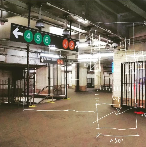
So many exits

I counted 9 total!
COURT STREET - BOROUGH HALL
#JustKeepSketching


WORK IN PROGRESS
I am trying to do something but it's not really going the way I want it to. So I just mindlessly Photoshop some textures, add some filters and shadows, and layer things on top of each other... this is a random moment that I quite like:

LEARNING FROM SEOUL
Just came back from Asia! This time I stopped by Seoul - nice city! It was a short trip but I managed to ride their metro a few times and notice some interesting things about the way signage is done.
This sign gives you the distance to the nearest exit in meters:

This one gives you the previous station and the next station (as opposed to the terminal station of that line):

And this one is a 2D map with 3D buildings - a hybrid. I am not sure how I feel about it, but I am intrigued!

HOBOKEN PATH STATION
As January has passed I am recharged and ready to get out and start drawing again.
I started this project two and a half years ago and named it with "NYC" because that's all I set out to do, to draw the NYC subway stations. Little did I know the high rent, tiny apartments and a series of life events would eventually urged me to look for an alternative down the road - I now live in Hoboken New Jersey. I still work in the city though so I commute every day by taking the PATH train. Which brings me to my point - I am going to try to draw the PATH stations. Starting with Hoboken where I live, and also the 33rd Street station because I already drew the 34th Street subway station and I have been promising people I would complete it by adding the PATH portion one day. I think it would be helpful to illustrate how the PATH stations in Manhattan intertwine with the subway stations!

currently reading
Winter's (especially THIS winter) too cold for me to go into the stations, so I decided I'll take January to read and organize my thoughts.


4"x6" postcards
Launching postcards of the X-ray series at the end of the year... test batch is looking good!
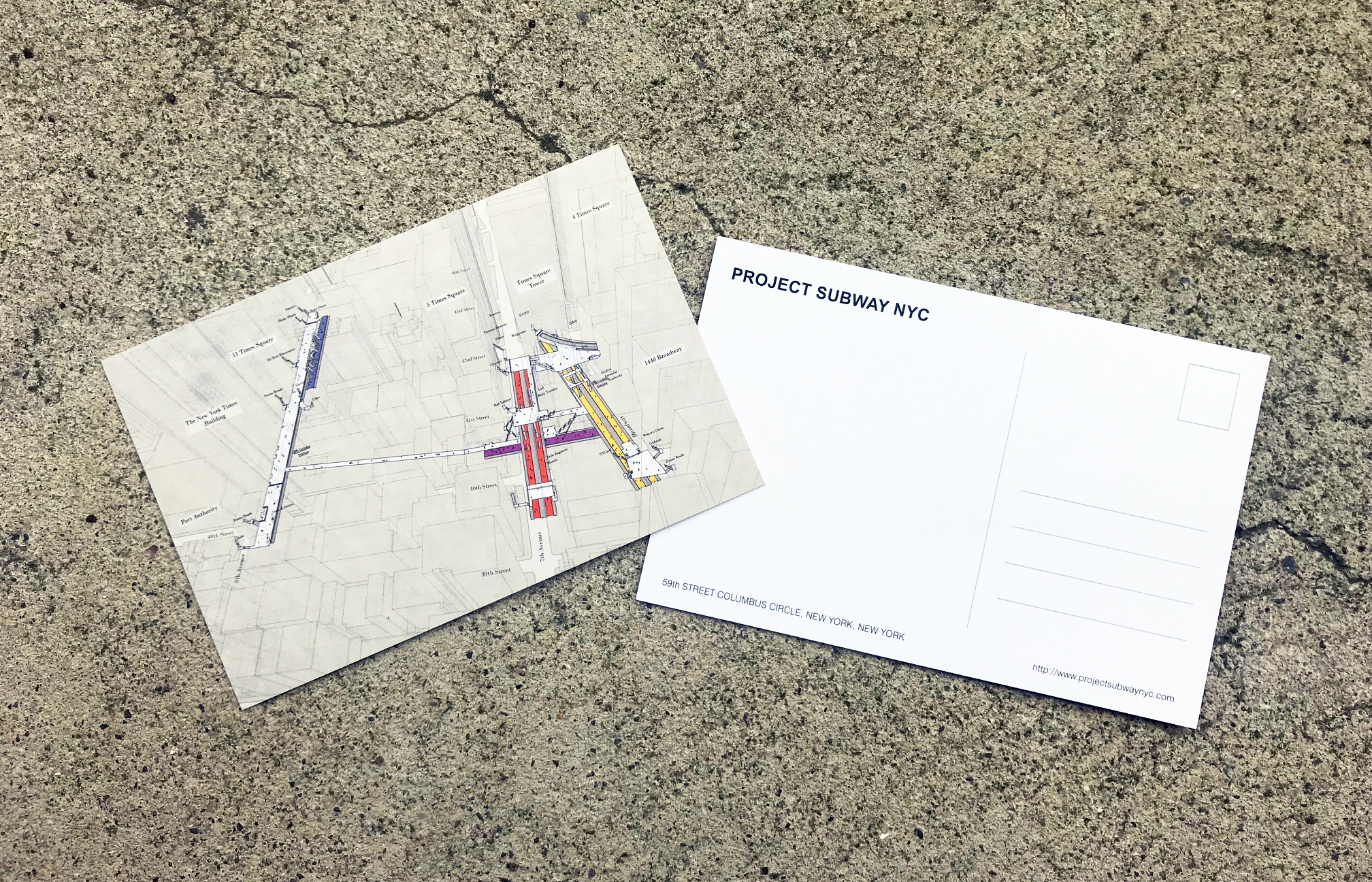
times square postcard - front and back
WE'RE ON TWITTER! #FOLLOWUS!
Project Subway NYC is finally on Twitter! Follow us @projsubwaynyc, we will keep you posted with the latest news about New York, transit, city planning, maps, architecture, graphic design, data visualization, wayfinding, and more! #followus #socialmedia

IT'S HERE: THE ATLANTIC AVENUE - BARCLAYS CENTER PRINT!
By popular demand, the Atlantic Avenue - Barclays Center print is finally ready! After four visits and God knows how many sketches. Check it out in our gallery and shop!
This is Project Subway NYC's second attempt to look into stations in Brooklyn, hope to do more soon. Let me know in the comment which stations you want to see, and don't forget to follow us on facebook and instagram (@projectsubwaynyc) for updates!
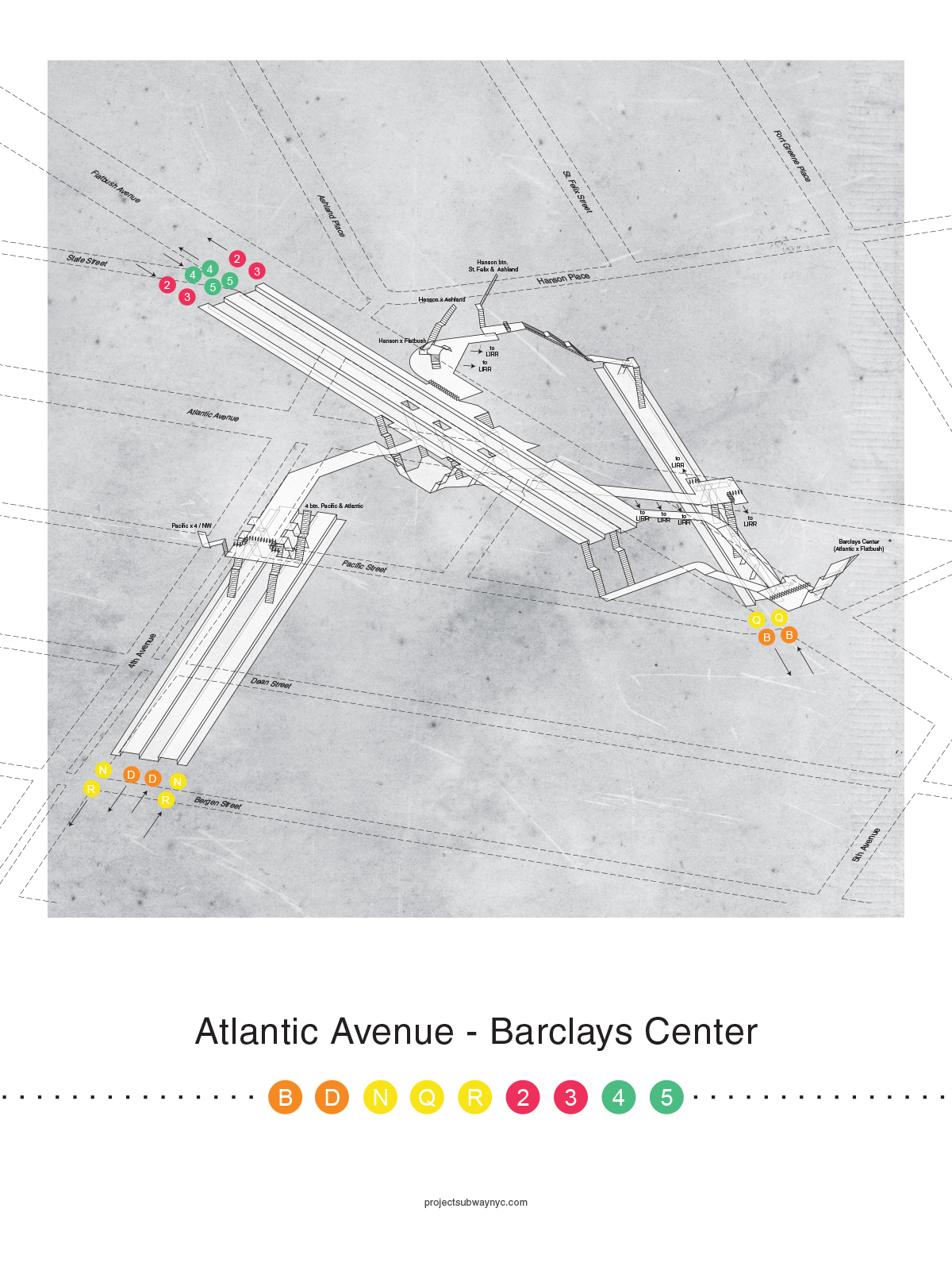
Atlantic Avenue - Barclays Center Poster

sketch - cad - print - sketch again
47th-50th street rockefeller center (B/D/F/M)
So even just looking at the name of the station you know this is another hard one... it spans 4 blocks right off the bat! Although, the reason this is a tricky one has more to do with the fact that it's a combination of a large complex that is the Rockefeller Center and the subway station itself. It's hard to draw the line between which is part of the station and which isn't, since there are a few spots underground where the station mezzanine connects directly to the buildings above ground, and some of them connect to concourses. I'll take more pictures next time!

47-50th Street Rockefeller Center sketch
Atlantic Avenue - Barclays Center
By popular demand, I have started to document the Atlantic Avenue - Barclays Center station. This station is no joke! This is my second trip, and we will keep counting...

Curved stair case following the shape of the corner building on Hanson Pl x Flatbush

Parallel to 2 / 3 / 4 / 5 platforms, connections to LIRR
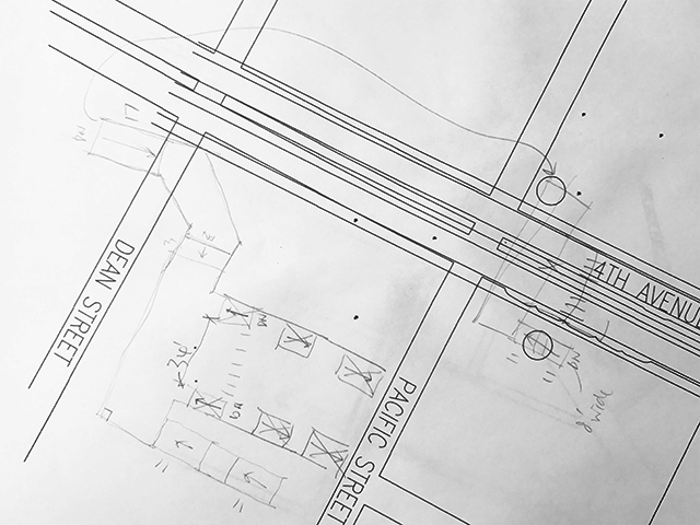
Second draft (pencil x hand) on first draft (computer x cad)
BEHIND THE SCENES - CREATING THE X-RAY SERIES
Last week was an exciting week for Project Subway! I released my new x-ray series and was thrilled to get some generally positive feedback. Thank you all for your love and support! Check out the coverage by CityLab and Gothamist if you haven't already :)
Since a few people have asked, I would like to share with you a little bit about my process. For the first part where I survey and sketch the stations, you can read about it here.
For the new series, I first download a 3D model of the city from cadmapper. Let me use the Union Square drawing as an example:
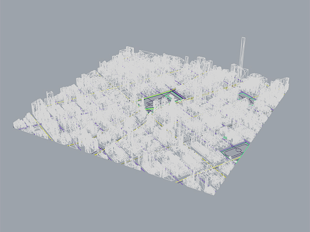
3D model from cadmapper.com (you can download up to 1 square km for free)
Then I find an angle that could work:

And I import the station model I made from before:
Then I go to Google Maps and get a general feel of the area, including trees, the configuration of the park, and the buildings:

Then I do some research on specific landmarks and transfer that detail into my drawing, for example, this clock thing (it's called the metronome) that always keeps people wondering:

metronome (source: wikipedia)

Then I export the lines into illustrator and edit the line weights:
Then I layer texture, streets, platform colors, people, and street names:

Textured underlay

Translucent white indication of streets

Colored platforms according to train lines

Added little people for scale

And finally street names and business names
And that was it! I repeated this process for all five images I made, took a few months!
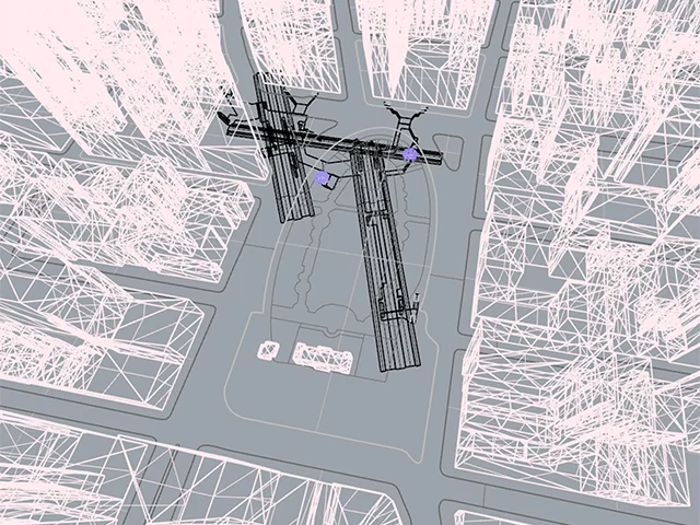
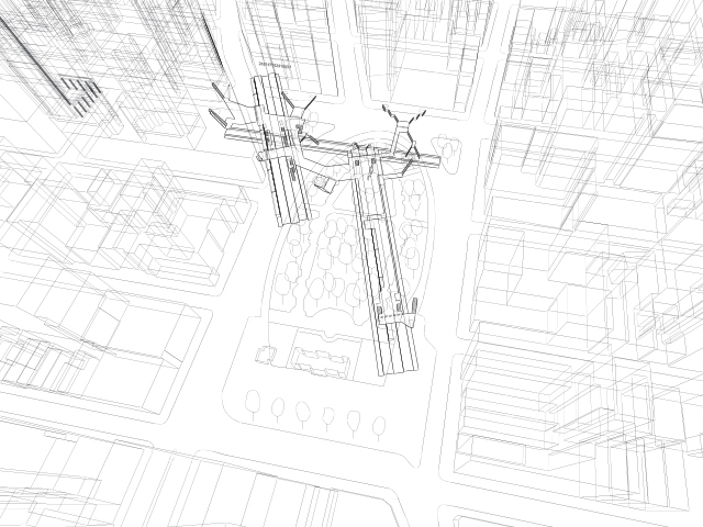
3D TRACK MAP TRAIL #2
Work in Progress -
NYC Subway 3D Track Map - Downtown

NYC Subway 3D Track Map - Midtown and Midtown West
I tried to model the entire area of Manhattan below Central Park in 3D but turns out the lines are too thin and the changes in elevations look to subtle when you zoom out in a bird's-eye view. So I had to exaggerate the width of the tracks. But after rebuilding the 2D lines in Rhino the lines look so wiggly, so it looks a little weird now. I will try to make a cleaner and neater version!
FOLLOW US ON INSTAGRAM!
Project Subway NYC is on instagram now - follow us @projectsubwaynyc !
Brooklyn Bridge - City Hall - Chambers Street station
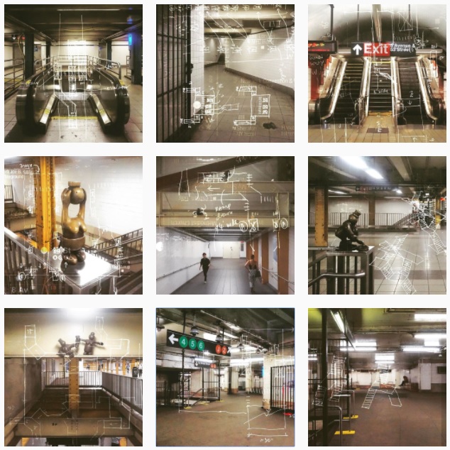
instagram - @projectsubwaynyc
3D TRACK MAP SKETCH
This is my first attempt

3D Track Map Sketch of the lower half of Manhattan
PUTTING IT TOGEHTER
So far I have been trying to study NYC's subway system one station at a time. Now that I have collected some twenty plus stations, I figure it's time I zoom out and look at how the stations relate to one another. When I put all the individual stations where they belong on the map, it looks like this:

Lower Half of Manhattan in Aerial View
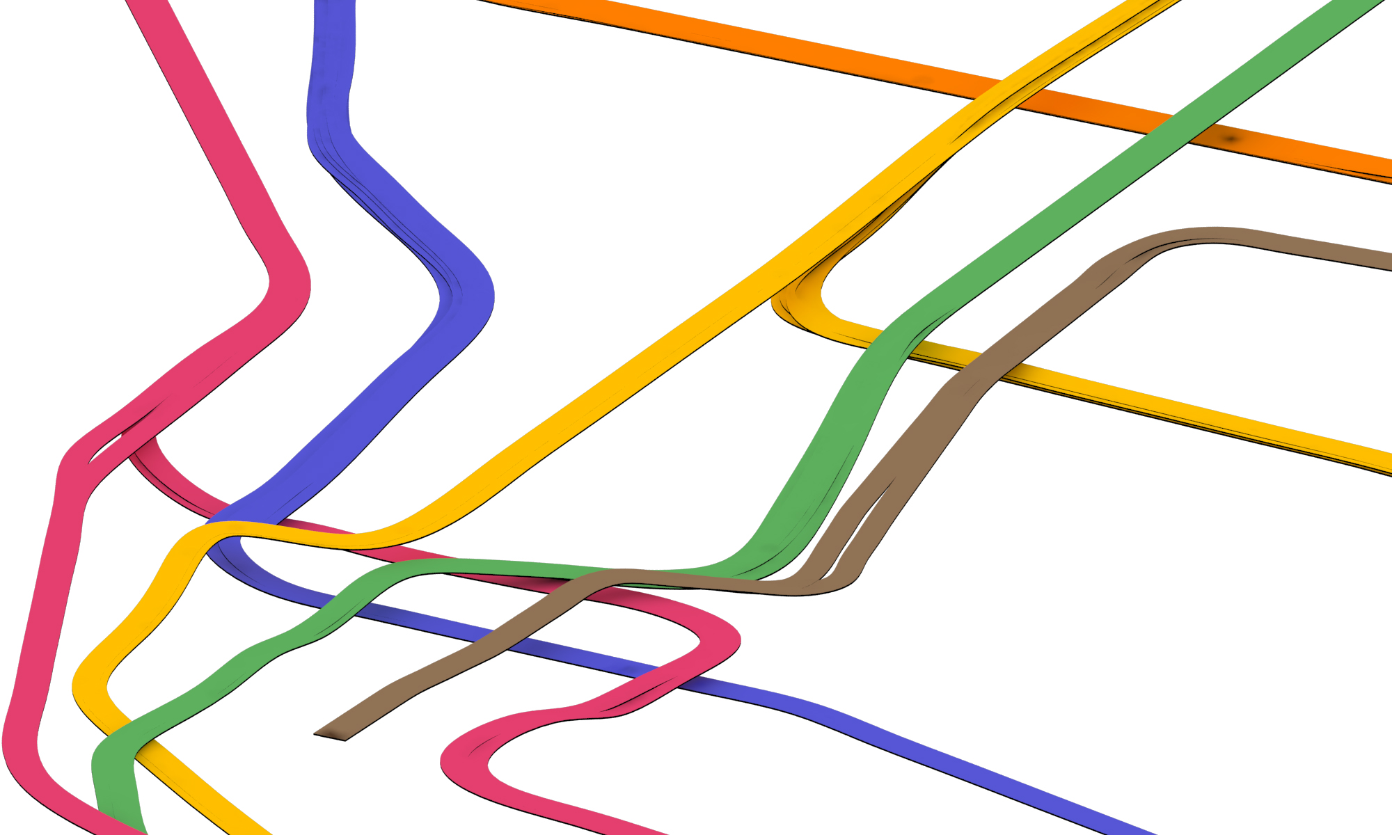
It gets tricky when I try to connect the dots - the tracks are really a vast network that gets interwoven together with a lot of ups and downs. Tracks that are parallel in one station sometimes get stacked on top of each other in another. They also split and merge, from local to express, and from inner to outer tracks. Here is my first attempt at figuring out the Columbus Circle area:

First Attempt at Sketching Tracks between Stations
Luckily nycsubway.org has a wealth of information to help me out. It has track maps that show which track is above which, like this:

Source: http://www.nycsubway.org/perl/caption.pl?/img/trackmap/detail-cityhall.png
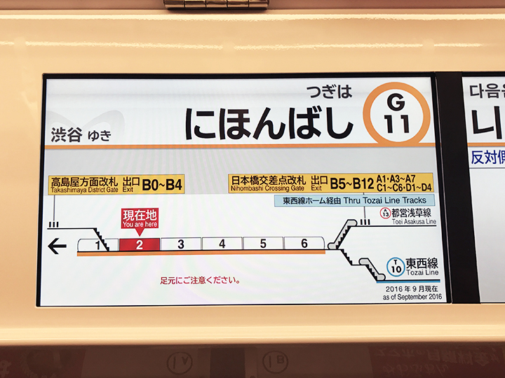
LEARNING FROM TOKYO
I went travelling in Tokyo back in February, and I was intrigued and inspired to see how graphics and information work in their subway system.
Even though I took on the quest to illustrate NYC's subway stations in 3D drawings, I have come to realize that because of the intricacy and complexity of the stations, a single drawing that shows one entire station often proves hard to understand. Therefore I have been looking for ways to represent the stations and directions in bite-size, easy-to understand information for subway riders.
In Tokyo, each train car has a digital display that shows the number of the car, the train's travel direction, as well as the location of escalators and elevators on the platform. Some of them also show transfer directions. My friend Ana told me that it was invented by a mom who could never get home on time because she was always lost in the stations - I find it very clever and helpful - comprehensive yet easy to understand!