23RD STREET STATION - A "SPLIT"

After tackling complex stations like Times Square and Herald Square, the 23rd Street station becomes relatively easy to survey and draw because it only has one line and therefore one level underground. Instead of going back and forth, I sketched out the whole station after one visit and it looks like this:

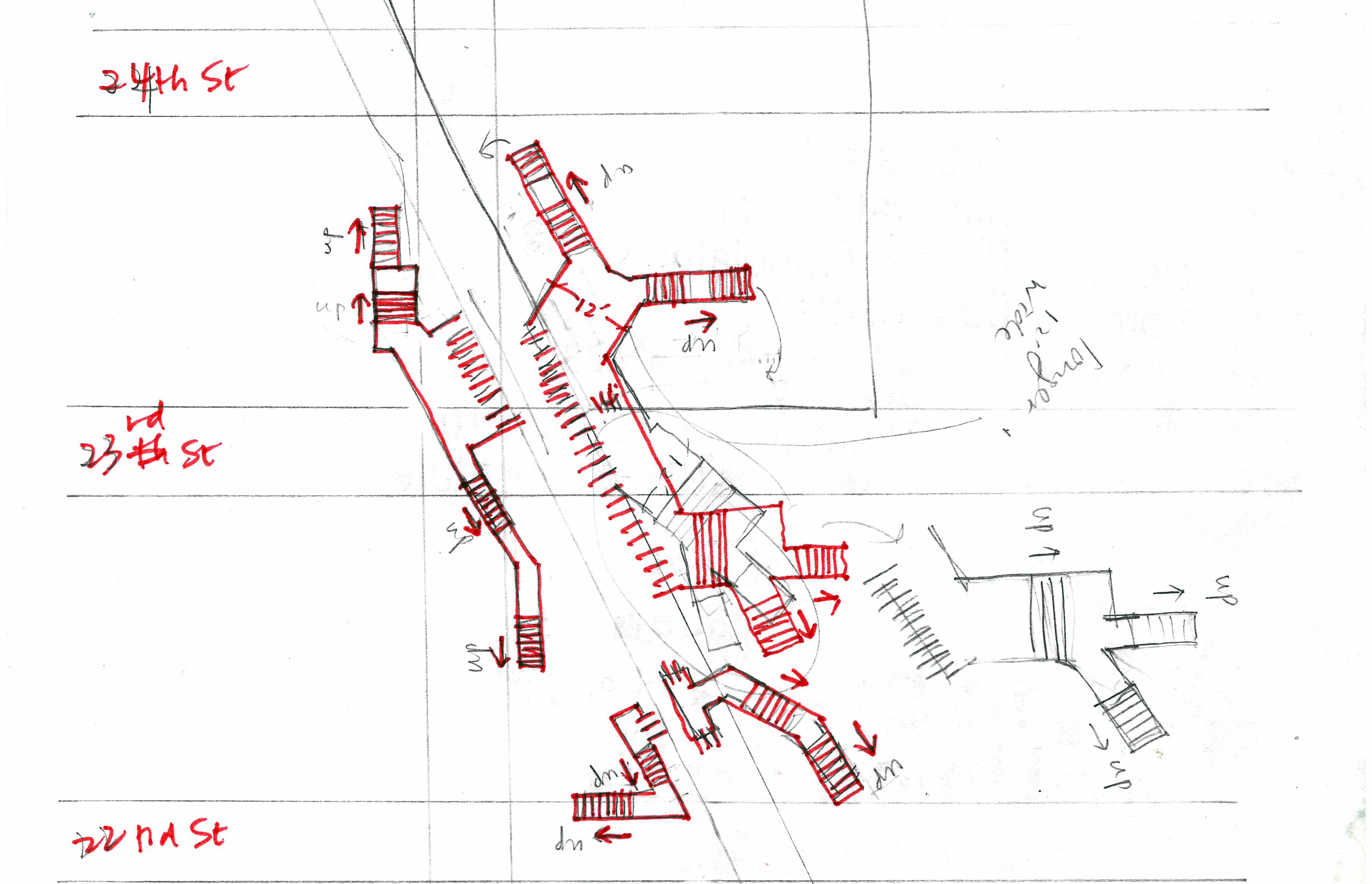
What is worth mentioning is that it is one of those stations that does NOT let you transfer between uptown and downtown trains inside the station. If you realized you need to reverse your direction of travel, you either have to leave the station, go across the street and swipe (and pay if you don't have a pass) again, or, you have to take the train to a station that does let you transfer and go back. 

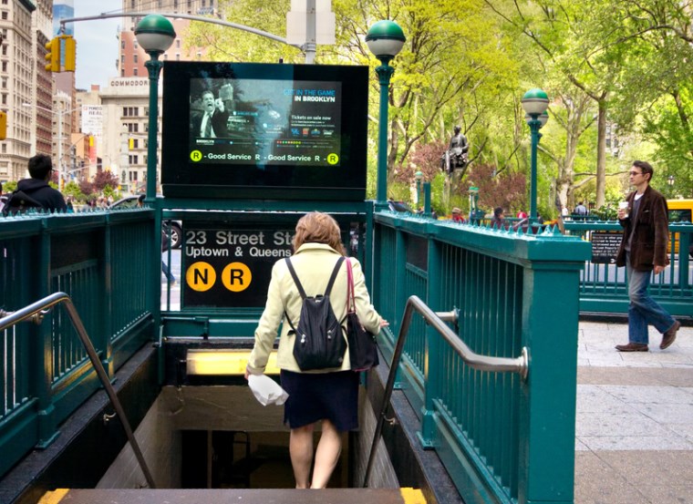
Of course, it does say so on the sign, that it's for "Uptown and Queens" only. But I think there should be a symbol for, and a term that describes, such stations. I would like to coin the term "SPLIT" here:

split

noun

  1. A subway station in NYC inside which you cannot transfer between uptown and downtown trains.

THE PROCESS

When I started this project, I naively thought I could just go walk around in the stations, take some pictures, and sketch the stations out casually like this:

But in reality, it was way harder than I thought. In order to work out where things are relative to each other, I had to developed a process to visualize the stations step by step. First, I document the entrances (from streets to turnstiles) on the neighborhood maps:

Then I make 2D drawings in the computer:

And then I go back and sketch some more, verifying my guesses and adding things I missed:

Then I model it in 3D:

And I render it:

And all of these steps kinda go back and forth and back and forth until I get the overall picture. The final graphic will be a combination of all of these. Almost there!

GETTING STARTED

I am an architect, so I am no stranger to surveying spaces from scratch. Still, it would be great to have something to base my drawings off of. To begin my quest, I went into the stations to look for the maps that tell you where the exits are. They look like this:

And so I thought alright, I’ll just have to go to each station to take a picture of the map. And then I thought, is there a chance these maps are online? So I went home and did a quick search and bam! Here they are:

Find all neighborhood maps like this one at http://web.mta.info/maps/neighborhood_maps.htm

Find all neighborhood maps like this one at http://web.mta.info/maps/neighborhood_maps.htm

They are called “neighborhood maps” under “maps” in mta.info

They are neither editable nor printable, but a quick print-screen will do. With them, I am ready to go out and take some actions!


SQUARE, SQUARE, SQUARE, SQUARE, CIRCLE…

There are more than 400 subway stations in New York, and ideally I would like to draw them all. 

But, like many things in life, I know if I aim too high, I will end up getting overwhelmed and giving up. As such, I have decided to start with five. Considering all the work that has to go in- taking pictures, collecting information online, surveying, modelling, drawing and photoshopping, five is already a handful, but hopefully it is manageable. 

The more complex and confusing stations are the ones with trains going in multiple directions, and to make it simple, I picked five stations along Broadway. 


Paradoxically, even though Broadway slices the rectangular Manhattan blocks into triangles and trapezoids, these intersections are all named squares and circles. (I know, I know “squares” have an ancient root, but I’m just saying.. :P) The list of stations I am going to start with is 14th Street – Union Square, 23rd Street – Madison Square, 34th Street – Herald Square, 42nd Street – Times Square, and 59th Street – Columbus Circle.
 

Pilot

It all started when my old office moved downtown to the financial district. The office is on Broadway, somewhere near the Fulton Street station. The station is HUGE -  there are so many exits that it was very confusing, and it took me and my coworkers forever to figure out how to get to the exit nearest to the office.

I am from Hong Kong, and in Hong Kong’s MTR (subway) stations, there are diagrams like these on the walls:

List of station layouts can be found here: http://www.mtr.com.hk/en/customer/services/system_map.html

List of station layouts can be found here: http://www.mtr.com.hk/en/customer/services/system_map.html

A quick search shows that Japan has similar:

And I thought to myself, why isn’t there any in NYC’s stations? Fulton Street is definitely not the only complex station, and I can't be the only person who wishes there is some form of visualization to help one find his way inside the station.

So I gave myself the challenge to make it happen, and this blog will be a record of this journey.